1. The coastal dune management area is located in New South Wales at Stuart Point.
2. 1893- A large flood caused the Macleay River to break through the sand barrier at South West Rocks creating another entrance for the river.
1965 May- Soil Conservation Service provided native plant seedlings and planting advice which was the start of the re-vegetation program for the dunes.
1965 August- Cattle started to grazed and destroy the vegetation program.
1970- Soil Conservation Service of NSW was established
Sunday, November 20, 2011
7.7
1. State governments
2. The Queensland government- Pays a 1/4 of the total of running and maintaining the sand bypassing system and carries out navigational dredging to keep open the river entrance.
The New South Wales government- Pays one half of the cost of running, is in charge of the sand bypassing system.
Gold Coast City Council- Pays a 1/4 of the total of running and maintaining the sand bypassing system, approval to carry out a certain amount of beach nourishment.
3. 2nd of June 1989- State ministers met to develop a cooperative approach to the issue of the Tweed River.
February 2000- Construction of the sand bypass scheme commenced.
March 2001- Scheme was completed and operational
4. The NSW government decided to halve the payments required while being given certain positions. The Queensland government and Gold City Council decided to half the other payment and each pay a quarter while receiving some duties. I believe this is fair because the NSW government decided to be apart of this scheme and should pay half.
5. The opportunities that the residents are given is to use the beaches and areas that are being managed by the scheme so that the governments and council can understand how the residents will use the area and what changes may need to happen.
7.4
1. Coastal management involves people creating solutions and strategies to minimise the environmental effects that humans put into the coastal region.
2. Sea Walls- Used to stop erosion of the coastline and protect property.
Breakwaters- Constructed at all the entrances to rivers, they extend into the ocean in order to stabilise river entrances.
Groynes- Constructed along beaches to catch sand and make beaches wider.
Fences- To ensure adequate access to the beach while protecting the vegetation that stabilises the sand-dunes.
3.
Sea Walls- Used to stop erosion of the coastline and protect property. | ||
Breakwaters- Constructed at all the entrances to rivers, they extend into the ocean in order to stabilise river entrances. | Keep river entrances clear of sand-build up. | |
Beach nourishment-Involves the movement of sand by machines. | ||
Coastal Dune preservation-Strategies are implemented to protect these dunes which play a vital role in the coastal environment. | ||
4. Because many management techniques work hand in hand with some management strategies which make them more effective and useful.
Sunday, November 6, 2011
7.2 Questions
7.2 Questions
1) Waves are formed in three stages by the action of the wind blowing across the ocean. First the wind forms ripples, then these form wavelets and finally waves.
2) The fetch is the distance the wind travels over the ocean to form a wave. It is an important factor in determining the size and speed of a wave as it is influenced by the strength of the wind and the length of the fetch.
3) Waves in the open waves cause things to move in an up and down motion only and tend to be contained and have a longer wavelength. Waves closer to the shore interact with the sea floor causing the speed to decrease, the wavelength to decrease and the top of the wave to travel faster than the base, cracking the wave.
4)

5)

6) Spilling Waves: These are fairly light waves which break far from the shore on beaches with gentle slopes.
Plunging Waves: Break on beaches where the slope is moderately steep. These are waves which create tubes for surfers to surf in.
Surging Waves: Occur on very steep beaches. The waves role up the steep face rather than breaking over it. They cause erosion.
7)Wind Swell: Marked by a short wavelength and high frequency of waves hitting the coast.
Ground Swell: Has a longer wavelength and the waves hit the coast less frequently.
9)
The three types of waves are:
Surging Waves – Don’t worry these are harmless and are found in very deep beach slopes with little waves.
Spilling Waves – These are slightly stronger than Surging Waves and are found in very shallow waters which break far from the coast.
Plunging Waves – These are very strong so be careful. These are found in moderately steep waters which cause tubes where surfers surf.
10) Today was a mild day and sunny day. As the time passed by the temperature began to rise and the wind started to pick up. by late afternoon there were some Ground swells so i put some flags up to indicate areas to swim in. As everyone left at 4 o clock lightning began to strike and the wind picked up immensely and in the distance i could see that there were cyclones beggining to form. This made me decide to close the beach for the rest of the day.
Monday, October 24, 2011
Chapter 7.1
1) Currently there is a trend for people to move from large cities to smaller coastal towns and villages where the lifestyle is more relaxed. This has caused a negative affect on the coastal line because the population is rising meaning that there is an increase in pollution. This can cause a health risk to humans. Also recreational activities like four-wheel driving places pressure on the infrastructure and environment of the area. If not carefully managed large dunes areas and beaches can be highly susceptible to erosion.
2) Because of all the inappropriate development the government now includes strict rules in an effort to ensure appropriate development. However, there are still poorly planned developments that alter the natural environment.
3) When Australians move from large cities to smaller coastal towns and villages where lifestyle is more relaxed
4) Some towns have imposed residential caps or a population ceiling for their town in an effort to stop over development of the area.
5) Inappropriate development, Pollution, Population Growth, Tourism and recreational pressures
Sunday, October 23, 2011
 | Ghost Tree
Some say its scarier than Maverick's, heavier than Waimea Bay and
among the most dangerous waves in the world. Wave faces can
reach heights of 70 feet, with a tube that stretches as long as a
football pitch across a boneyard of black rock. In 2007 this spot
sadly claimed the life of a local surfer-it is a serious wave.
Ghost Tree is located near Monterey Bay, California, just off the 18th
hole at Pebble Beach Golf Links. In the four years since it was first
towed into, it has become one of the planet's most discussed surf
spots and from this picture you can see why.
|


Statistics for 23 Oct (1981–2005) – mean: 14.7 °C, range: 13.6 °C to 16.6 °C (mean 58 °F, range: 56 °F to 62 °F)
|
Sunny with pleasantly warm air temperatures (feels like 24 °C / 75 °F) at Ghost Tree, yet the sea remains several degrees colder than the air. Most surfers will need a spring wetsuit though a summer suit or even a shorty may suffice for a short session.
Below is a graph of Historical Sea Surface Temperature for Ghost Tree. This has been derived from analysis of two decades of oceanographic satellite measurements of nearby open water. We have calculated the average water temperature variation around the year as well as the extremes that have been observed on each date.

All of the graphs for the surf breaks presented on Surf-Forecast.com are on the same scale to enable comparison between locations around the world.
Ghost Tree sea water temperatures peak in the range 14 to 18°C (57 to 64°F) on around the 22nd of September and are at their minimum on about the 7th of April, in the range 11 to 14°C (52 to 57°F). The warmest seasonal sea water temperatures at Ghost Tree in the second half of September lend themselves to a 4/3mm wetsuit or a 3/2mm suit and 3mm neoprene boots. The minimum sea water temperatures at Ghost Tree in the first part of April are ideally suited to a 4/3mm wetsuit + 3mm boots, although a 5/3mm wetsuit may be preferable for longer sessions and cold windy days.
Actual sea surface water temperatures close to shore at Ghost Tree can vary by several degrees compared with these open water averages. This is especially true after heavy rain, close to river mouths or after long periods of strong offshore winds. Offshore winds cause colder deep water to replace surface water that has been warmed by the sun. Air temperature, wind-chill and sunshine should also be considered before deciding on the kind of wetsuit needed to stay warm when surfing at Ghost Tree. Refer to our detailed weather forecasts for this information.
|


Monday, September 12, 2011
Chapter 4.3
1. Federal- The Australian Government's Department of Transport and Regional Services.
State- The NSW Department of State and Regional Development Funds
2. Sense of Place Program and Townlife Development Program
3. The rural transaction centre is the first ever community-owned post office in Australia created by the towns people of Gulargambone after there was threat of closure of the local post office. It is important because it provides needs of the community
4. The GRTC is a first community-owned post office in Australia. It offers Giro post, Centre link, Medicare, Internet access and the reliance credit union along with the usual postal services and a small but modern gift shop
5. Community groups have have lobbied government and non-government organisations for funding and assistance. Without the proactive attitude of the community and individuals, Gulargambone would not have the services and facilities that are available today.
6.
1) To increase the population and services that are available
2) To improve the visual appearance of the town
3) To promote Gulargambone
7) The two eight two eight project involved the restoration of the former picture theatre into a vibrant and multi-faceted community centre.
8)
The opening of the rural transaction centre
Lobbying for and receiving a new multi-purpose health centre
The 'Back to Gulargambone reunion'
9) Coonabamble Shire Council has provided funding and help with many of the projects undertaken in Gulargambone including dollar-for-dollar funding for repainting the shops in the main street and funding the feasibility study for the Rural Transaction Centre. It has been supportive of the Gulargambone ahead program and has provided assistance for the many projects
10) The changes that have occurred include:
- New textures used to build the building
- Different colours used to produce the building
- Crack have been filled leaving the building look attractive
But overall their has only been a slight improvement between the two buildings
11) Active citizenship is extremely important to the little town of Gulargambone. Many individuals have been involved in the many projects mentioned earlier. The town relies heavily on volunteers who run the two eight two eight cafe and the library and who give up their time to make sure that Gulargambone survives despite rural decline.
12)
a) The article is about the community coming together in order to save their town known as Gulargambone
b) The downturn in rural economy and the ravages of drought
c) Over a couple of decades, the residents saw their busy main street drained of its energy as one shop after another closed, banks left town and services were removed
d) The threat of closing the post-office
e) Because it was the only post-office close to the community
f) Old picture theatre, a cafe, gift shop, exhibition centre, and best of all, regular movie nights
Thursday, September 8, 2011
Questions 4.2
1) It causes economic hardship for agricultural population which has an effect on businesses and jobs, increased welfare dependency
2) It meant that there were more farms available but there are less farms actually running
3) The soldiers settler blocks being sold, collapse in the wool industry, rising costs in the agricultural industry with fuel, machinery and wages
4) It has meant that these more advanced and more powerful machinery such as headers are able to harvest bigger areas of land in one day making the farmers job a lot easier which means they don't need as many employees
5) Because of the improvement in roads and cars it gives people better access to wider communities such as Dubbo and Coonamble which means they are able to bypass smaller and more isolated towns such as Gulargambone. People also find it easier to use particular services and facilities with entertainment in larger towns and communities than smaller ones
6) People have left the town to search for employment and education, the age median is increasing which means there is a greater need for age services
8) The population dramatically declined from 1954 to the mid 1960's, from then and on the population has been going up and down. From starting with a population of 900 people Gulargambone has lost 500 people.
9) The reason why the population is appeared in a pyramid is because it is an easier way to tell the population through all of the ages. The pyramid covers all the ages from 0-80 and presents a clear population throughout all of the ages
10)
a- The school enrolments slowly rose in the 1950's and from there has been a major decline up until 2007
b- The reason why the trends are shown like this is because over the past 30 years the town has experienced steady population decline. There are large numbers of children, but many young people aged 15-29 have left the town and its surrounds in search of education and employment. The median age is increasing showing that there is an ageing population and a greater need for aged services
11)
Social- The median age is increasing
Economic- People are leaving the town to find better employment
Environmental- Drought and decline in Agriculture
Questions 4.1
1. Rural decline is when Australians migrate from rural areas to urban areas which makes the land suffer.
2. Gulargambone is a small rural town located on the Castlereagh River, halfway between Gilgandra and Coonamble in the central - west region of New South Wales.
3. Gulargambone has a temperature climate with periods of extreme heat in summer, up to 45 degrees Celsius, and cold in winter, down to -5 degrees Celsius. The average annual rainfall is 580-595 millimeters and it can be highly variable. The town lies on the Castlereagh River that is usually dry - it flows underground. the terrain id flat to undulating and the soils are fertile black and red types.
4. The town before the 'soldier settler' blocks had only 2 residents, but most of the returned soldiers were young men. When they settled in the area they brought with them wives and young families. This created a mini-boom in the population during the 1950s and 1960s.
5. Agriculture and Forestry.
6. 447 people live in Gulargambone. 1072 people living in the district.
7. The Community Development Employment Program.
8.
b.
i. North West
ii. North.
iii.West.
9.
a.
i. Bourah 31 18 S and 147 16 E
ii. The Maze: 31 21 S and 148 17 E
iii. Tailby State Forest: 31 15 S and 148 22 E
iii. Tailby State Forest: 31 15 S and 148 22 E
b
i. AR6254
ii. AR6353
iii.AR6151
10. 4.30 has the biggest area.
Mapping Skills
Source A-C
What is the predicted population growth rate in 2030? 0.75%
What is the predicted population change in 2030? 60 million people
What region of the world is predicted to have the greatest gross increase in percentage between 1800 and 2050? Africa
Source D
How many males and females are there in Ethiopia for the age range 60-64 in the year 2000? 2.5 million people
How many males and females are there in Italy for the age range 60-64 in the year 2000? 1.75 million
Why do you think that there is such a difference between these two countries? Because Italy is smaller and has more of a great diversity of ages as apposed to Ethiopia which is a developing country.
Source E
What is located at GR831979? Dicks Hill
What is the highest point at AR7997? 490 metres
What is the contour interval for the map? The way in which mountains are shaped and how high they go.
What physical feature is located at GR820975? A wet swamp
Approximately how far is the Laurieton Sporting Complex from Hanleys Point on the Camden Haven Inlet? About half kilometer from the centre of the complex to the edge of the inlet
Give the GR for the North Haven Public School. GR830000
What is the highest point at Camden Head? Give the height and GR. 79 meters and GR845989
Tuesday, September 6, 2011
Go Back To Where You Came From
What is your initial reaction to the show? My initial reaction to the show is that it is a good way to see the really stories behind the refugees and rather than the bias stories in the news saying that they are bad, it shows the struggle of them and what they go through.
What percentage of immigrants are refugees? 1.5%
Why does such a small number of people make for such a big deal both politically and in the media? (Give your opinion) I believe that it is made such a big deal of because the people who make a big deal of it can as opposed to the people going through it which view is never heard.
Where does Australia rank among countries accepting refugees? We are number 18th in the world
To what extent do we have an obligation to help other people suffering in the world? (your opinion) I believe that Australia does have the right to help others in the world especially in developing countries because Australia is a thriving country.
How much extra support do refugees receive in comparison to other Australian citizens? They receive equal once they are settled in Australia (i.e. medicare) and also Australia tries to help legitimate refugees. 0.8% as much as the Australian citizens.
How many Asian nations have signed the UN Refugee Convention?11 Asian Nations have signed the UN refugee convention.
Why is it important to note that Malaysia has not signed the UN Refugee Convention? What does this mean for refugees in Malaysia? Malaysia does not recognise the rights of refugees as defined in the convention, nor does it have the same responsibilities as signatory countries by not being part of the UN refugee Convention. This means that it would be harder for refugees in Malaysia to settle in other countries.
Monday, August 22, 2011
Wednesday, August 17, 2011
Work
''I'm not racist, but . . .'' this is the beginning of a racist comment and I have not ever heard anyone say this
We need to act together, without delay, to eradicate racism and racial inequality in all of its forms - to find a solution
How has Australia changed in your life time?
Physical
Socio-economic change
Cultural Change
- Droughts
- Floods
- Building of the Olympic Park
We can find out about the physical changes through research on the Internet or from past documents and other sources of information. We can also use old weather charts to find out about the droughts and floods that happened in Australia.
Droughts
Australia has suffered severe droughts in its northern and eastern regions during many EL Niño years. These droughts have reduced crop yields, killed livestock, eroded soils and encouraged destructive bush fires. The El Niño event of 1982-83 coincided with a drought that may have been the worst for 100 years. The 1982 winter rains failed over the south-eastern grain and pasture areas of Australia. In northern New South Wales and southern Queensland, the summer rains also failed. The drought was broken in the autumn of 1983 by torrential rains in eastern Australia. Sheep, weakened by the drought, suffered severely: many were drowned or starved, and foot-rot caused many lengthier deaths.  |
Socio-economic change
- Financial Crisis
- More money in Australia
- Mining
We can find out about the socio-economic changes by looking at old financial records of Australia through the years. We can find out if Australia is continuing to gain money or if it is continuing to lose money. But we don't know what will happen in the future.
Mining
The mining industry has been a great turn around for Australia and its socioeconomic status within the world. Since Australia is a relatively new country it has many resources available such as a major fuel, coal. This is very good for Australia's economy because China, a country that is booming with a growing population is in demand for coal and Australia has to coal they need. This means that Australia even in a GFC is able to grow as a country and have more money within there economy.
The mining industry has been a great turn around for Australia and its socioeconomic status within the world. Since Australia is a relatively new country it has many resources available such as a major fuel, coal. This is very good for Australia's economy because China, a country that is booming with a growing population is in demand for coal and Australia has to coal they need. This means that Australia even in a GFC is able to grow as a country and have more money within there economy.
Cultural Change
- Asylum Seekers
- The Stolen Generation
- More woman in parliament
- Population
Cultural changes have happened throughout Australia but where can we find information? From the Stolen Generation we can find out information through carvings on rocks, stories told by the ancestors and even past documents written at the time. This is basically the same with the others.
The Stolen Generation
"The Stolen Generation" is a phrase, which is now familiar to most Australians. It speaks of the suffering and sometimes permanent damage caused to many Aboriginal children unjustly removed from their families and frequently raised in institutions. This essay will look at the issues brought about from the stolen generation, the role of the government as well as the long lasting effects.
The stolen generation occurred between the years 1910 and 1970 mainly in rural Australia. It involved the removal of full blood aboriginal children as well as "half-castes" from their families, to be placed in institutions or foster care with a white family. The negative consequences of removing the children cannot be under estimated. For the majority of people involved, the effects have been "multiple and profoundly disabling."
Wednesday, June 8, 2011
Evaluation - Project
Adam: as normal completed his work, helped others and got information. He did well to complete the assignment and even though he was finished with his part he managed to complete Morgan's work as well.
Morgan: did well at the start by getting information and completing his maps. However when it came to the fact sheet he refused to do it and Adam had to do it. He would have done well if he hadn't been so arrogant.
That is all Andrew
Morgan: did well at the start by getting information and completing his maps. However when it came to the fact sheet he refused to do it and Adam had to do it. He would have done well if he hadn't been so arrogant.
That is all Andrew
Wednesday, May 11, 2011
2.6 Questions
1- 1974
2- They set up evacuation and medical centres
3- The National Disaster Organisation is a federal government body and it became involved with cyclone Tracy to help restore basic services to Darwin
4- To save lives
5- 80.459% of Darwin’s population were evacuated
6- Houses in all cyclone-prone areas of Australia must adhere to strict building codes to withstand cyclone. Also lessons have been taught how to prepare against this hazard
7- On the 29th of August Hurricane Katrina hit the Gulf of Mexico and the state of Louisiana in the United States. It killed over 1400 people and flooded large areas of New Orleans
8- When the hurricane hit, the storm surge combined with the low-lying nature of the New Orleans meaning that 80% of the city became flooded.
9- All levels of Government were criticised for the slow and disorganised response to the hazard
10- The NDO was quick and organised to send out food supplies and medical services while the FEMA was criticised for being slow and took days to send out food supplies
 11-
11- 12-
a) Cyclone Tracy was heading at a fast speed South-East straight through Darwin
Monday, May 9, 2011
2.7 Questions- Destruction by Tropical Cyclone Larry
1. On the 20th of March, the eye of Cyclone Larry crossed the coast near Innisfail between 6:20am and 7:20am.
2. They experienced the greatest damage because it caused major flooding and left many communities isolated for several days.
3. Public infrastructure are things such as roads, rail and air transport that the public uses. The damage was brought on the infrastructure made if very difficult to transport nessessities such as food, water and shelter to the effected areas.
4. The total damage bill as AU $350 million.
5. Cyclone Larry destroyed 85% of the banana crops in North Queensland. It left thousands of people without employment and $298.4 million were lost from the destruction of the crops.
6. The Emergency Management Australia and State Emergency Service both help to produce information brochures on natural hazards and run community workshops to ensure that people are well prepared.
7. Emergency Management Australia, State Emergency Service, Australian Defence Force, charities and government departments.
8. They helped the coordination of the recovery effort and helped provide large quantities of resources needed to remove danger and repair damage.
9. Major General Peter Cosgrove. He would need to have good leadership qualities and be able to organise large groups of people to help with the recovery effort. He would need patience as the recovery would take time.
10.
11. It would interrupt the supply of bananas for weeks and maybe months as so much of the crop was lost and many factories exporting the bananas would be impossible to get to with the flooding.
12. a) 800km
b) 66.6 km/h
c) It was downgraded to a tropical low at 1am on March 20th. This is because the wind had lost its momentum that it gained over the sea.
d) It travelled around 1000km inland before it receded.
2.5 Questions – Tropical Cyclones
1) If the air pressure in the upper atmosphere is relatively high it will limit the altitude that the warm, moist air can rise to. This high pressure causes the rising air to spiral outwards thus forming a tropical cyclone.
2) They form in the tropic of Capricorn throughout November through April.
3) The most areas that are at risk in Australia are Queensland and the Northern Territory.
4) 6 are likely to cross the Australia’s coastline per year.
5) The other names for tropical cyclones are Typhoons and Hurricanes.
6) Tropical cyclones develop in the tropical regions of the world. Heat from the sun causes warm, moist air to rise into the atmosphere. As the air rises, a low pressure system forms and condensation occurs, which releases latent heat causing the air to rise further into the atmosphere is high, then the rising column of warm air will spiral outwards in the upper atmosphere and air will rush from the surface to replace it, forming a tropical cyclone.
7) The eye of a tropical cyclone is the middle where there is a pipe-like hollow centre.
8)
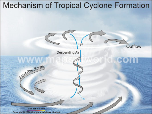
9) The tropical cyclone is downgraded to a tropical storm when it moves to cooler water and loses its energy supply of warm, moist air.
Subscribe to:
Comments (Atom)